 |
|
|
About
Malaria
The KNP
falls in a Malaria Risk area. To significantly
reduce your risk, take precautionary measures
against mosquito bites throughout the year.
Prophylactic
medication is recommended from Sep to May for all
visitors.
Please
consult your doctor for more info, or see the web
site of the Malaria Research Programme
(SA Medical Research Council)
|
|
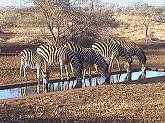
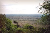
Day Trip
East of Hazyview
There is something
very, very large to the east of Hazyview.
Its size is 2 million hectares.
It is the world renowned Kruger
National Park.
| Location |
Phabeni
Gate: 14km (R536)
Kruger Gate: 43km (R536)
Numbi Gate: 21km (R569) |
| GPS |
Phabeni
Gate: 25° 01' 30" S | 31° 14' 29" E
Kruger Gate: 24° 58' 51" S | 31°
29' 06" E
Numbi Gate: 25° 07' 52" S | 31°
08' 12" E |
Entrance
Gate Times |
Month
Dec-Jan-Feb
Mar
Apr
May-Jun-Jul
Aug-Sep
Oct-Nov |
Open
05:30
05:30
06:00
06:00
06:00
05:30 |
Close
18:30
18:00
18:00
17:30
18:00
18:00 |
| Restaurant
Hours |
Breakfast
Lunch |
07:00 - 09:00
12:00 - 14:00 |
|
Conservation
Fee
(/person/day)
|
SA Citizens
SADC Nationals
Other Nationals
|
1 Nov 21 to 31 Oct 22
R110/adult, R55/child
R220/adult, R110/child
R440/adult, R220/child |
|
Telephone No. |
KNP
Skukuza
Medical Doctor
Breakdown
Police |
013 735-4000
013 735-5638
013 735-4260
013 735-9004 |
|
|
Trip
Advice for KNP
Get off to
an early start. Be at the entrance gate even
before it opens.
Purchase a
map and plan your drives around the rest camps,
picnic spots and other places where you are
permitted to exit your vehicle.
Remember
to take along binoculars, cameras (and spare
batteries), reference books, sun-block cream,
cooler bag and, if your are allergic to insect
stings, your medication.
Drive
slowly. Slower than 30km/h is advised.
Experience
the total biodiversity of the Park - not just the
Big-5.
Alcoholic Beverages
Your are not permitted to take any alcoholic
beverages into the KNP. Your vehicle and cooler
boxes may be searched by Park Rangers.
|
|
|
 Getting There Getting There
Total Distance:
13km (to Phabeni entrance gate)
Time Required: All day
The closest entrance gate to the KNP is the Phabeni
Gate (14km from Hazyview). From the centre of Hazyview
take the R536 east, towards the main Kruger Gate.
Then turn off to the right after 11km to the Phabeni
Gate (the turnoff is well signposted).
|
Please
don't drive over our dung.
You are killing my relatives!
|
|
 Recommended Routes from Hazyview Recommended Routes from Hazyview
Southern Kruger
(Hazyview ~ Phabeni Gate ~ Skukuza ~ Lower Sabie ~ Crocodile
Bridge ~ Berg-en-Dal ~ Pretoriuskop ~ Phabeni Gate ~
Hazyview.)
Enter at the Phabeni
Gate and drop in at Nyamundwa Dam (10km along the S1 road
towards Skukuza). Drop in at Lake Panic Hide (S42 turnoff
just before Skukuza). Consider having breakfast at Skukuza
Rest Camp.
Continue with the
H4-1 road towards Lower Sabie and pull into the Nkuhlu
Picnic Spot (25km from Skukuza). Stop at the Sunset Dam,
just before Lower Sabie (this rest camp is another good spot
for a breakfast). Continue on the H4-2 road towards
Crocodile Bridge and turn off after 6km on the S28 gravel
road - stop after 7km at the Ntandanyathi Bird Hide. Travel
on the S137 gravel road (for 9km) back to the H4-2 tarred
road and proceed towards Crocodile Bridge. Stop at the
Gasanftombi Dam just before Crocodile Bridge.
Turn off on the S25
gravel road towards Berg-en-Dal. Turn off on the S119 and
stop at the Gardenia Bird Hide. Continue with the S119 and
S114 gravel roads towards the H3 tarred road. Turn off on
the S110 road to Berg-en-Dal Rest Camp (good spot to have
lunch).
Drive back on the
S110 to the H3 tarred road and head north towards Skukuza.
Stop at the Afsaal Picnic Spot (31km from Berg-en-Dal). Turn
off on the H1-1 tarred road towards Pretoriuskop Rest Camp.
Visit the Transport and Shitlhave Dams before reaching
Pretoriuskop. Continue on the H1-1 road towards Numbi Gate
for 5km and turn off on the S7 and then the S3 gravel roads.
Head for the S1 tarred road and turn left towards Phabeni
Gate and onwards back to Hazyview.
Southern-Central
Kruger
(Hazyview ~ Phabeni Gate ~ Skukuza ~ Tshokwane ~ Satara ~
Skukuza ~ Kruger Gate ~ Hazyview)
Enter at the Phabeni Gate and drop in at Nyamundwa Dam (10km
along the S1 road towards Skukuza). Drop in at Lake Panic
Hide (S42 turnoff just before Skukuza). Consider having
breakfast at Skukuza Rest Camp.
From Skukuza take
the H1-2 road to Tshokwane. Visit the Mantimahle,
N'watindlopfu and Silolweni Dams on the way. Tshokwane is a
great spot for a picnic breakfast. Take the H10 road for 1km
and then turn off on the S32 gravel road to visit the Orpen
Dam viewpoint. Continue with the S32 to the H1-3 tarred road
and drive north towards Satara. Drop in on the Mazithi Dam
and visit the southern-most Boabab tree on the way (25km
from Tshokwane). Satara Rest Camp can also be considered for
a late breakfast.
From Satara drive
back on the H1-3 road for 5km and turn off on the H6 road.
The Sweni Bird Hide is 22km along this road. Head back to
Tshokwane, either along the H6 and H1-3 tarred roads, or
with the S37 gravel road. Drive from Tshokwane back to Skuza
and exit at the Kruger Gate before returning to
Hazyview. (Be cautious on the Kruger Gate / Hazyview
road, especially at dusk. Be on the lookout for goats,
cattle, taxis and pedestrians).
|
|

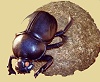
Elephant Shrew
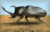
Rhino Beetle

Red-billed Buffalo-weaver

Leopard Tortoise
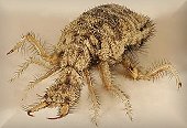
Ant Lion
|
Landscapes of Kruger
Taking
into account the climate, geomorphology,
vegetation and faunal composition, the KNP can
be categorised into a number of landscapes,
where each landscape may be considered an
ecosystem in its own right.
More
info ....
|
|
Kruger
National Park
(Southern)
Hazyview, located close to the Kruger National Park
(KNP), is the ideal springboard for day visits to the
southern KNP. Most of the Lodges and Guest Houses
will gladly pack you a breakfast hamper for an early
start. Drive there in your own vehicle or experience
the thrill of a game drive in open Safari Land Rovers.
The KNP - located
in the north-eastern corner of South Africa on the border
with Mozambique - represents one of the most distinctive
ecosystem-orientated national parks in the world because
of its:
- large size,
- pristine ecosystems, and
- large biodiversity
Size
The KNP covers an area of 20,000 km2 (2
million hectares) and stretches over 350 km from north to
south. The southern section of the KNP is 80km wide from
east to west, but the central and northern sections are
only about 45km wide. A number of large, unfenced
private game reserves are located on the western boundary
of the KNP. The Limpopo National Park in Mozambique
borders the KNP in the north-east. Together this forms the
Great Limpopo Transfrontier Park - a combined area of
about 55,0000 km2.
Topography
The greater part of the KNP is a more or less
flat area with occasional rocky outcrops. The terrain
slopes gently from the west to the Lebombo mountains in
the east. Height above sea level varies between 840m
near the Malelane gate to 440m at Punda Maria in the
extreme north. The central part is about 260m in
altitude and the lowest point (at 122m) is at the Sabie
River Gorge where this river enters Mozambique.
Geology
The KNP is roughly bisected from north to
south by a sandstone ridge. The western half consists
mainly of granite and its products of erosion as well as
outcrops of dolerite. The eastern half consists
mainly of basaltic formations. Soils vary from heavy clays
to deep sands.
Rainfall
The rainy season in the KNP starts in
September/October and lasts until March/April, followed by
a period of very little or no rainfall. About 80% of
the precipitation occurs in the form of quick but erratic
thunderstorms. In the south-west (around Pretoriuskop rest
camp) the rainfall is as high as 760mm/annum, but this
drops to as little as 210mm in the north-east (near
Pafuri).
Temperatures
Average daily maximum temperatures in the KNP
varies between 30°C (in January) to 23°C (in July), but
can be as high as 47°C in January and 35°C in July.
Average night minimums varies from 18°C (in January) to
8°C (in July), but can be as low as 7°C in January and
-4°C in July. Occasional light frost occurs, mostly
in low-lying areas.
Vegetation
According to Acocks' classification (Acocks
1975) the KNP comprises of three major vegetation
zones:
- Lowveld, comprising the southern area from the
Crocodile river in the south to Tshokwane in the north,
- Arid Lowveld, in the central area from
Tshokwane in the south to the Olifants river in the
north, and
- Mopane Veld, comprising almost the entire
remaining area of the KNP north of the Olifants river.
|

Elephant (±12,000)

Rhinoceros (±5,000)
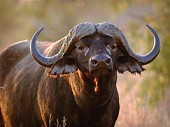
Buffalo (±2,500)
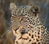
Leopard (±1,000)

Lion (±1,500)
|
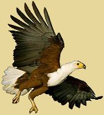
Birding Big-6
Be on the
lookout for:
- Saddle-billed Stork
- Kori Bustard
- Martial Eagle
- Lappet-faced Vulture
- Pel's Fishing-Owl
- Ground Hornbill
Also
see our dedicated Birding
Page
|
|
|
|
|
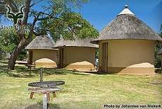
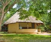
Rest
Camps
The Kruger National
Parks offers camp-run accommodation to tourists. Each camp
has its own unique selection of accommodation types, ranging
from camping to luxury lodges.
All accommodation, ablution and
kitchen facilities are serviced by cleaning staff on a
daily basis. Bedding is supplied in all accommodation
units (except camping). Cooking utensils and refrigeration
are provided in most units.
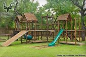
The KNP also caters for the day
visitor with day-visitor areas, picnic spots, bird hides,
restaurants, curio shops, wild-life displays, museums,
game drives, and swimming pools.
Experience
the African Bushveld at it's very best!
|

Statue of President Paul Kruger
at the Kruger Gate
|
|
|

© SANParks.org 2004-2012
More
info ..
|
Pretoriuskop Rest Camp
GPS: 25° 10' 00"
S | 31° 15' 57" E
Pretoriuskop, situated in the south-western corner of the
Kruger, is the oldest rest camp, and exotic flowering plants
were allowed to stay (as an exception to the general rule
prevailing at other rest camps), to enhance the strong sense
of the past.
|
© SANParks.org 2004-2012
More
info ..
|
|
|

© SANParks.org 2004-2012
More
info ..
|
Lower Sabie Rest Camp
GPS: 25° 07' 09"
S | 31° 54' 58" E
Lower Sabie is located on the banks of the Sabie River, one
of the few perennial rivers to flow through the Park.
Characteristic of the camp is it giant sycamore fig trees,
which support prolific bird and insect species. These trees
produce fruit at least twice a year and different trees
produce fruit at different times, extending the fruiting
season over many months. Game and bird watching from the
elevated wooden deck overlooking the Sabie River is very
rewarding.
|

© SANParks.org 2004-2012
More
info ..
|
|
|

© SANParks.org 2004-2012
More
info ..
|
Berg-en-Dal Rest Camp
GPS: 25° 25' 10"
S | 31° 27' 05" E
Berg-en-Dal is situated on the bank of the Matjulu
watercourse with a view of undulating hills to the east. On
the northern and southern sides dry riverbeds and a dam
border the camp. Large trees are dotted along the streams
and dry riverbeds. Special care has been taken to preserve
the natural vegetation in the camp. Berg-en-Dal is also the
only camp set in a rugged mountain environment and is built
on the site of prehistoric settlements.
|

© SANParks.org 2004-2012
More
info ..
|
|
|
|
Skukuza
The name Skukuza is a corruption of the Zulu word
"sikhukhuza", meaning "He who sweeps/scrapes
clean". This was the Zulu nickname of the
first Warden of the Park, Col. J.
Stevenson-Hamilton and refers to his determination
in evicting hunters and poachers from the (then)
newly proclaimed Reserve.
|
|
Skukuza Rest Camp
GPS: 24° 59' 41"
S | 31° 35' 25" E
Skukuza is the KNP's largest camp and also the Kruger's
administrative headquarters. It is situated on the southern
banks of the Sabie River. The camp is well foliaged and
there are some lofty trees along the river's edge.
Other facilities include a par
72, 9-hole Golf Course (available Sundays to Fridays), the
Stevenson-Hamilton Memorial Library, Post Office, Bank,
Internet Café, Swimming Pool, Cell phone reception, and
the Skukuza Indigenous Nursery (5km outside camp. Open
Monday - Thursday: 08:00 - 16:00).
|

© SANParks.org 2004-2012
More info
..

© SANParks.org 2004-2012
More info
..
|
|
|

© SANParks.org 2004-2012
More
info ..
|
Crocodile Bridge Rest Camp
GPS: 25° 21' 30"
S | 31°° 15' 31" E
A small camp, situated in the south-eastern corner of the
Kruger, on the northern bank of the Crocodile River, which
forms the southern boundary of the Kruger. The game viewing
area is known as the 'Southern Circle' and is renowned for
its concentration of numerous prides of lion. It is home to
a larger percentage of the Kruger's total rhino population.
|
© SANParks.org 2004-2012
More
info ..
|
|
|
© SANParks.org 2004-2012
More info
..
|
Satara Rest Camp
GPS: 24° 23' 52"
S | 31° 46' 42" E
Satara is a busy camp, and not without reason. It is
situated in an excellent game viewing area, with the bush
relatively open and the animals plentiful and diverse. The
camp itself has a rustic charm, with the bulk of the
accommodation set out in a series of circles. Satara is well
wooded and the bird-life is prolific.
|
LIVE Web Cam
at SATARA
|
|
|

|
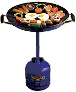
Picnic Spots
Most of the main rest camps have an area set
aside for picnics and day visitors. In addition to
these, there are a number of other picnic spots throughout
the Kruger. Gas skottels (mobile frying pans on gas bottle
stands) can be hired at most picnic sites for a nominal fee.
Some of the larger picnic spots also have convenience shops.
- Afsaal
GPS: 25° 16' 46" S | 31° 31' 40" E
21km north of Malelane, next to the tarred road between
Skukuza and Malelane.
- Nkuhlu
GPS: 24° 59' 56" S | 31° 46' 00" E
18km east of Skukuza on the southern bank of the Sabie
River, between Skukuza and Lower Sabie.
- Mlondozi Dam
GPS: 25° 02' 07" S | 31° 55' 56" E
10km north-east of Lower Sabie. The picnic spot is in top
of a hill to the south of the dam wall.
- Tshokwane
GPS: 24° 46' 35" S | 31° 51' 21" E
Midway between Skukuza and Satara, next to the
N'waswitsontso Creek.
- Eileen Orpen
GPS: 24° 47' 40" S | 31° 53' 56" E
Picnic spot overlooking the Orpen Dam, 4.5km east of
Tshokwane.
|
|
Beware!
Don't leave your food unattended. Monkeys, baboons
and some birds have become masters at grabbing a
quick meal.
And by
feeding them (even unintentionally) your are
condemning them to be shot one day as problem
animals.
|
|
|
|
View from Nkumbe

Hippo Pool

Rabelais Hut
|
Other Get-out Points
In addition to the Rest Camps and Picnic
Spots, there are also a few other spots were you are
permitted to leave your vehicle.
- Albasini Ruins
GPS: 25° 01' 14" S | 31° 14' 25" E
Situated 16km north-west of Pretoriuskop on the western
bank of the Phabeni Creek, near the Sabie River.
- Stevenson-Hamilton's grave
GPS: 25° 06' 13" S | 31° 35' 46" E
Grave of the first warden of the Park. Located 16km south
of Skukuza on the S114 road.
- Hippo Pool
GPS: 25° 22' 01" S | 31° 52' 08" E
On the Crocodile river, 7km south-west of Crocodile Bridge
on the S27 road.
- Kruger Tablets
GPS: 24° 52' 29" S | 31° 46' 15" E
A granite hill, 13km south-west of Tshokwane, next to the
main road between Skukuza and Tshokwane.
- Nkumbe Viewpoint
GPS: 24° 51' 16" S | 31° 53' 25" E
A 394 meter high hill, 8.5km south-east of Tshokwane.
- Orpen Dam
GPS: 24° 47' 40" S | 31° 53' 56" E
Viewpoint over dam in the N'waswitsontso river, 4,5km east
of Tshokwane.
- Rabelais Hut
GPS: 24° 26' 34" S | 31° 28' 16" E
Historical place, 2.5km south-east of Kingfisherspruit on
the old Orpen road to the east of the N'wamatsatsa drift.
|

Albasini Ruins

Steven-Hamilton's Grave

Kruger Tablets

Orpen Dam
|
|
|
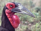
Ground Hornbill
|
Bird Hides
There are four bird hides in the southern
Kruger where you are also permitted to get out of your
vehicle. These bird hides are, of course, also great
places to watch for other wildlife activity and not just
for birding or bird enthusiasts. Most of these hides have
no public conveniences.
- Lake Panic
GPS: 24° 59' 16" S | 31° 34' 32" E
An earthen dam serving as an emergency reservoir in the
Mafunyana Creeek, 1.5km north-west of Skukuza.
- Ntandanyathi
GPS: 25° 12' 35" S | 31° 57' 20" E
Waterhole in the Shimangwana Creek, 10.5 km south-east of
Lower Sabie.
- Gardenia
GPS: 25° 22' 25" S | 31° 36' 27" E
located on the S25, S119 junction near Malelane.
- Sweni
GPS: 24° 28' 30" S | 31° 36' 40" E
Located 25km east of Satara, near the private Singita
Sweni Lodge.
|

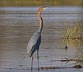
Goliath Heron
|
|
|
Other
Day Trips
Close
to Hazyview | North
of Hazyview | South
of Hazyview | West of
Hazyview
|
|
|
home
| about | contact
| biodiversity | accommodation | health spas |
cuisine | to do | adventure |
golfing | birding
| shopping | sitemap
www.hazyviewinfo.co.za
copyright Trips ZA, 2012 - 2022
|